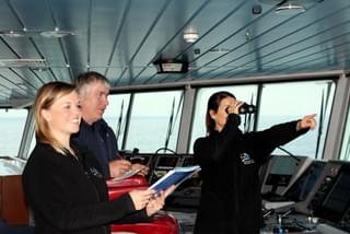
Sea Safari
Experience whales and dolphins with ORCA and join us out at sea.
Data collected by ORCA’s volunteers Marine Mammal Surveyors on board the UK-based ferry network is actively used to identify needs and create better protection for whales and dolphins around the UK and the wider North-East Atlantic.
We use a process called distance sampling. This is a standard method for estimating cetacean populations, and with repeated surveys over time, we are alerted to any rise or fall in populations.
ORCA has carried out distance sampling surveys from ferries and occasionally cruise ships since 2006 at a minimum of once a month per route. This repeated, regular-as-clockwork process results in very comprehensive and valuable data, often in marine zones that are otherwise difficult to access. It also enables us to detect changes, which can then be flagged for further research, management efforts or action by statutory authorities.
We help JNCC to meet its obligations under the UK’s Habitats Regulations 2017, particularly with regard to monitoring harbour porpoise and bottlenose dolphin populations. Our data provides an ongoing and real-time snapshot of the health and well-being of our marine mammal populations.
ORCA volunteers on board ferries are actively helping Nature Scotland and Marine Scotland define marine protected areas around Scotland under the Marine (Scotland) Act 2010. Our survey data has already been used to create a Marine Protected Area (MPA) for Risso’s dolphins in the Hebrides.
Our collaboration with the Marine Ecosystems Research Programme which brought together colleagues across 33 academic, governmental, non-governmental, and voluntary organisations representing a dozen countries to collate a huge data resource of cetacean and sea bird observations in the north-east Atlantic, covering seas from Norway to Portugal.
This study is the most comprehensive analysis of at-sea surveys for the North-East Atlantic and represents a transformative step in our understanding of where and when these species are to be found. The creation of cetacean seasonal distribution, ranging across seasons and geographical areas, will inform decision-makers for marine protected area planning and marine management including adverse effects of offshore renewable energy installation, risks posed from bycatch, shipping activities and offshore developments.
You may also be interested in